CPEC is China’s force multiplier in the “String of Pearls” strategy for encircling India
Maj Gen Sudhakar Jee
As India is emerging as a global power in the Indian Ocean Region, China has undertaken a “strategic encirclement” of India by developing infrastructure. The China-Pakistan Economic Corridor (CPEC) with the Karakoram Highway as its backbone and the China-Myanmar Economic Corridor (CMEC) both are aimed at providing access to the warm waters of the Indian Ocean.
Moreover, China has also ramped up infrastructure development all along its Western and Southern borders with India. Most of these infrastructures have the dual-use capability for both civil and military use, and therefore have serious security ramifications for India along the Line of Actual Control (LAC).
Hotan-Kangxiwar Highway (G-580)
This 10000 km road runs along the entire western and southern border of China from Kom-Kanas Mongolian Ethnic Township in Xinjiang to Dongxing in Guangxi. This axis enables a speedy inter-sector mobilization, build-up, and rapid deployment of PLA troops and resources against India in all three sectors: Eastern Ladakh in the western sector, Himachal Pradesh and Uttarakhand in the middle, and Sikkim and the Arunachal Pradesh in the eastern sector. In case of a two-front war, this axis can be easily exploited by connecting it with the Karakoram Highway, the backbone of CPEC, in support of operations by both Pakistan and China against India.
Extension of G-219
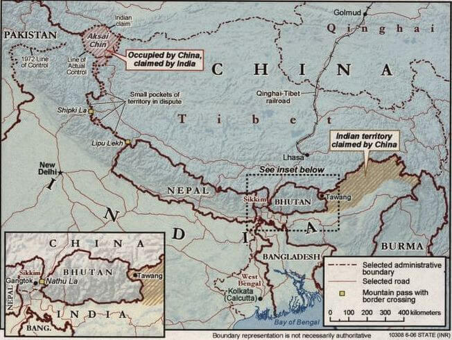
The G-219 highway runs along the western and southern borders of China between Xinjiang and the Tibet Autonomous Region through the disputed Aksai Chin. China has built at least eight key roads towards the LAC from the G219 highway including roads from Kangxiwar in China’s southwestern Xinjiang region to the Karakoram Pass in the north and from the salt water Lake Tianshuihai in the Xinjiang region towards Galwan valley and its north. It has also constructed roads connecting Sirijap at Finger-8 at the north bank of the Pangong Tso Lake to G-219. Further south along the LAC, it has constructed roads from South of Shiquanhe running towards Chumar in eastern Ladakh.
Moreover, it has also built a new jetty at Finger-8 on the north bank of Pangong Tso and has deployed about 50 patrol boats at the lake. This capability would provide a battalion-sized force at any given time.
These additional road constructions and the up-gradation of existing roads will ensure that China will have direct road connectivity to areas opposite important Indian military posts along the LAC, from Daulat Beg Oldie (DBO) in the north to Galwan Valley, Pangong Tso, and Chumar in the south.
Hotan-Ruoqiang Railway Line
The Hotan-Ruoqiang railway is a new single-track line that runs through the edge of Taklimakan Desert in Xinjiang Uygur Autonomous Region, north-west China. The 825 km-long railway line is the final part of the Taklimakan Desert railway loop. The project will enable faster and more comfortable travel on the route between Qiemo county and Hotan city.
Bridge over Pangong Tso
China is building a second bridge on the Pangong Tso to further facilitate its rapid deployment of troops across the 700-sq-km Pangong Tso Lake that separates Indian and Chinese military deployment in south-eastern Ladakh. The bridge is around 25 km inside the territory controlled by the Chinese Army near the Khurnak Fort area around Rutog.
Once completed, the bridge will be used to transport heavy military vehicles like tanks, and armored vehicles very close to the Indian border. Earlier, the Indian Army had put China on the back foot by capturing the peaks located on the southern bank of Pangong Tso Lake in the Kailash Range. It is assessed that the aim of China would be to prevent such action in the future.
The lateral connecting G-219 and the second bridge at Pangong Lake at Sirijap near finger-8 threatens the very base of the 256 Km long strategic road Durbuk Shyok-Daulat Beg Oldi (DS-DBO) of India. China perceives this road as a threat to the safety of G-219 and Karakoram Highway in the area. Aksai Chin in eastern Ladakh is an important part of a grand strategic design of the Chinese to extend their reach to the Karakoram Pass.
China has also built a major road link to the Shaksgam Valley, part of the old Gilgit Agency ceded by Pakistan to China in 1963, in order to facilitate the construction of the Karakoram Highway. It is the world’s most glaciated region, and the valley is known to have 242 glaciers. China requires new sources of fresh water to sustain its growing needs, hence eyeing access to Shaksgam valley which lies west of the Siachen glacier.
G-6 Expressway
In the eastern sector, China is quickly building the G-6 expressway from Xining to Lhasa, to connect Tibet’s capital to Beijing. The new stretch of 1,897 km from Xining to Lhasa includes a 546-km section beyond the Tanggula pass in Tibet. All the tunnels being constructed on the Tibetan side are twin tunnels — each almost 15-20m wide. Using this route, PLA logistics convoys would be comfortably able to cover the distance of 3,725 km from Beijing to Lhasa in four days or less during emergencies.
India’s Response
India is also ramping up infrastructure close to the LAC by constructing of roads, bridges, helipads, and habitats for additional troops. The Border Roads Organization (BRO) is busy connecting isolated locations along the northern boundary. The BRO’s capital budget has been boosted by 40 percent from Rs2500 crore in 2021-22 to Rs3500 crore in 2022-23.
The Hanuthang-Handanbroke-Zungpal-Turtuk road in Ladakh is expected to reduce travel time to 3.5 hours from the current nine hours between the Indus Valley and the Shyok Valley. A road connecting Pooh in Himachal Pradesh to Chumar in Ladakh is also close to completion.
India has made significant strides to improve connectivity in this sector including bridges on the Chenab River, Banihal-Qazigund Road Tunnel, Zojila Pass Smart Tunnel, 9.02 Km long Atal Tunnel under Rohtang Pass, and the introduction of patrolling boats in Pangong Tso Lake. But there is still a need to develop at least three more tunnels to improve the last mile connectivity at Khardung La, Chang La, and Marsimik La.
Despite the challenges of the high altitude and rarefied environment, India and China have a combined deployment of about one lakh soldiers along with a huge presence of tanks and artillery at LAC after the 2020 standoff in Ladakh.
The great game is on in the Himalayas and the India ocean region, and China cannot afford a hint of losing out, given its precarious internal politics and exuberant middle class fed on macho nationalism. India is wisely playing the waiting game of knowing the enemy better and drawing them near to hit at the time of her own choosing as advised by Sun Tzu in “Art of War.”

(Maj Gen (Rtd.) Sudhakar Jee, VSM is a former colonel of the Mahar Regiment. He has commanded troops in varied terrain, climate, and conflict zones. Currently, he is pursuing a doctoral thesis on the India-China border dispute.)
==
Disclaimer: The views expressed are not necessarily those of The South Asian Times